English| USD
Suggested for you
More currencies
Choose a language
Reunion's active volcano is not a technical climb, yet it defeats more visitors than its modest summit figures suggest. The trail from Pas de Bellecombe drops into a caldera before it rises, so the hardest section waits at the end. This piton de la fournaise hike difficulty guide sets out the grade, the ground underfoot, and who should turn back.
Quick answer
The route is rated moderate to hard: roughly five to six hours return, about 520 metres of ascent, and a full re-climb out of the Enclos Fouqué caldera on tired legs. There is no entry cost — access is free — and no technical skill required. The real limiters are exposed lava rock, altitude near 2,632 metres, and weather that shuts the trail without warning.
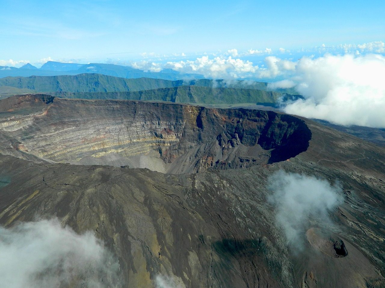
The summit of Piton de la Fournaise sits at 2,632 metres, yet walkers begin the day by going down. From the belvedere at Pas de Bellecombe, a fixed metal staircase and ladder section drops around 150 metres onto the floor of the Enclos Fouqué, the horseshoe caldera that has contained most of the volcano's eruptions since 1700. That inversion is what makes piton de la fournaise hike difficulty hard to read from a map. The gentle-looking outbound leg is downhill; the return is a sustained climb at the point when reserves are lowest. Ground conditions do the rest of the work. Beyond the ladder, the path crosses pahoehoe and aa lava — ropy, glassy, and in places sharp enough to tear a palm on a stumble. White paint splashes mark the route across Plaine des Sables-style terrain where no worn trail exists, so navigation depends on visibility rather than fitness. Cloud typically banks up the eastern flank from late morning, and once the marks disappear the sensible response is to stop rather than improvise. Formica Leo, the small scoria cone near the start, is a common turnaround point for families; Cratère Dolomieu, the active summit crater, is the full objective and roughly ten kilometres of walking away in each direction. Altitude compounds fatigue without causing real sickness at this height, though visitors arriving from sea level at Saint-Denis or Saint-Pierre often feel it on the ascent back out. The volcan de la Réunion is also a live geological site: the Observatoire Volcanologique du Piton de la Fournaise monitors seismic activity, and prefectural alerts close the Enclos entirely during unrest, sometimes for weeks. Any assessment of Reunion volcano trail difficulty therefore has to account for closure risk alongside physical grade. Read honestly, the walk suits a regular hiker with solid ankles, no fear of exposed metal stairs, and the discipline to abandon the summit when cloud arrives. It is unsuitable for anyone unsteady on uneven rock or unwilling to carry their own water across shadeless terrain. Reunion National Park hiking of this kind rewards conservative decisions: reaching Formica Leo and returning in clear air is a better day than a blind push toward Dolomieu. Use the difficulty rating to set a personal turnaround time before leaving the car park — the sections that follow cover timing, route steps, access, and what to bring.
“The trail's hardest kilometre is its last, because the way back out of the caldera is entirely uphill.”
This walkthrough breaks the Pas de Bellecombe crater route into its physical stages, from the descent into the Enclos Fouqué to the rim of Dolomieu. Most walkers spend five to six hours on the round trip, covering roughly 11 kilometres with around 500 metres of cumulative ascent on the return.
From the Pas de Bellecombe belvedere at 2,311 metres, take the roughly 520 metal and stone steps that drop about 170 metres into the Enclos Fouqué caldera. The steps are steep and often wet, and the descent quietly banks a climb you must repay at the end of the day when your legs are tired.
Follow the white paint marks across the flat, black pahoehoe and clinkery aa lava toward Formica Leo. The ground looks easy and level, but the crust is abrasive and uneven, so ankles roll and hands get cut when people speed up here.
Navigate solely by the white dots painted on the rock, checking that you can see the next mark before leaving the last. There are no handrails or continuous trodden path, and fog can reduce visibility to a few metres within minutes.
Begin the sustained ascent up the flank of the cone, gaining roughly 400 metres over loose scoria and hardened flows. The gradient is relentless rather than technical, and the loose gravel wastes energy by sliding underfoot with each step.
Walk the rim path along the crater edge, staying well back from the fractured, overhanging lip. The edge undercuts invisibly and unstable blocks sit close to the drop, so the marked line matters more than the view.
Reserve roughly half your strength for the reverse journey, which ends with the full staircase climb back to Bellecombe. Walkers who empty their reserves on the summit typically add an hour or more to the final ascent.
Optimizing your start time is the most effective way to manage the physical demands of the Piton de la Fournaise hike. The best arrival window is 06:00–08:00 to mitigate heat-related exhaustion and minimize navigation risks caused by afternoon cloud cover.
Hot and humid, 20°C–25°C
Trails are strenuous due to high solar exposure and heat.
Cool and dry, 10°C–18°C
Clearer skies improve visibility but require extra thermal layers.
Mild temperatures, 15°C–22°C
Often provides the most stable weather for long-distance trekking.
—
Starting between 06:00–08:00 avoids midday heat and peak visitor numbers.
Verdict: For the optimal balance of lower heat and clearer visibility, plan your ascent for a weekday morning between April and October.
The trailhead for the Piton de la Fournaise hike is located at Pas de Bellecombe, Sainte-Rose, 97439, Reunion. Access is primarily achieved by private vehicle, as no public transportation services reach the parking area.
Route Nationale 3 (RN3) to Bourg-Murat, then follow signs for Route Forestière du Volcan
Route Forestière du Volcan from Bourg-Murat
The final section of the Route Forestière du Volcan is a gravel road that requires careful driving. Plan to arrive between 06:00–08:00 to secure parking and avoid afternoon clouds.
The crossing of the Enclos Fouqué is a lava-field walk with no shade, no water and sharp rock underfoot, so gear does most of the work of managing the difficulty.
Piton de la Fournaise is accessible daily, remaining open around the clock to accommodate various hiking schedules.
Everything you need to know about piton de la fournaise hike difficulty
The trail is considered demanding due to significant elevation changes and rough volcanic terrain. Evaluating the piton de la fournaise hike difficulty involves acknowledging the uneven, rocky surface of the caldera which requires sturdy footwear.
While children can complete parts of the path, the full route to the crater is long and strenuous. Parents should assess the piton de la fournaise hike difficulty based on their child's stamina and previous experience with high-altitude trekking.
Beginners may find the route challenging because of the steep descent into the Enclos Fouqué and the subsequent climb. It is recommended to maintain a steady pace to better manage the piton de la fournaise hike difficulty throughout the day.
Yes, weather conditions such as fog, wind, and intense sun significantly impact the terrain and visibility. These factors can increase the perceived piton de la fournaise hike difficulty, making it essential to check forecasts before starting.
Hikers should have a good level of cardiovascular fitness and balance to navigate the loose volcanic scree safely. Preparation and proper hydration are key to overcoming the physical challenges presented by this landmark.
The initial descent from the Pas de Bellecombe-Jacob and the final climb back up are the most taxing sections for most visitors. Managing energy levels during these segments is crucial for a successful trek.
The main trail is clearly marked with white paint spots on the lava rocks. Following these markers helps hikers stay on the correct path across the vast volcanic landscape.
Entry to the site is free for all visitors. You do not need to purchase a ticket to access the trailhead at Pas de Bellecombe.