
English| USD
Suggested for you
More currencies
Choose a language
Réunion's active shield volcano is one of the rare places on earth where a marked footpath crosses a live caldera floor. This piton de la fournaise walk guide explains what the terrain actually demands, where the route begins, and what governs access on any given morning. The trailhead sits at Pas de Bellecombe, Sainte-Rose, 97439, Reunion.
Quick answer
The walk costs 0 EUR — free entry to the hiking area, with no gate fee for the trails themselves — and the access road and viewpoint are open every day, 00:00–23:59. The caveat that matters more than any figure: the route is weather- and alert-dependent, and the national park can close the Enclos Fouqué descent at short notice during eruptive or seismic activity.
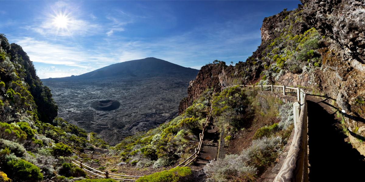
The volcano erupts roughly every nine months on average, which makes Piton de la Fournaise one of the most reliably active in the world — and means the ground underfoot on this walk is, in geological terms, brand new. Lava fields crossed by hikers in 2026 did not exist a generation ago. The route begins at the Pas de Bellecombe belvedere on the rim of the Enclos Fouqué, the horseshoe caldera that contains almost all of the volcano's activity. From there a stairway drops roughly 160 metres to the caldera floor, and the piton de la fournaise walk proper begins across the black basalt plain toward Formica Leo, the small ochre scoria cone that serves as everyone's first landmark. What follows is not technical, but it is exposed. There is no shade on the caldera floor, no water source, and no phone reception in parts of the basin. Route-finding depends entirely on white paint blazes daubed on the rock, and those blazes are the reason cloud is the real hazard here rather than gradient. When mist rolls up from the east coast — often before midday — the marks vanish at ten paces and walkers lose the line. The full ascent to the Dolomieu crater rim is a long day out; shorter Réunion volcano tours turn back at Formica Leo or at the Chapelle de Rosemont, which is a legitimate outing rather than a failure. The practical consequence is that this hike is governed less by fitness than by information. The Observatoire Volcanologique du Piton de la Fournaise monitors seismicity continuously, and the Préfecture raises alert levels that can close the Enclos to the public within hours. A barrier at the top of the stairway carries the current status; the national park publishes it at reunion-parcnational.fr. Checking that page the night before, and again at the belvedere, is the single most useful habit a visitor can adopt — several of Réunion's landmarks tolerate improvisation, and this one does not. Weather compounds it. The Plaine des Sables approach road climbs through a lunar expanse of red gravel that can be fogbound while the coast is clear, and returning walkers frequently describe leaving sunshine at 2,300 metres and driving down into rain. Anyone planning a piton de la fournaise walk should treat the forecast, the alert bulletin and the cloud base as three separate checks, then build the day around whichever is least favourable.
“Route-finding depends entirely on white paint blazes daubed on the rock, which is why cloud, not gradient, is the real hazard here.”
The best arrival window for your Piton de la Fournaise walk is 06:00–08:00. Arriving during this period avoids the frequent afternoon cloud cover and ensures parking availability at the trail start.
Cool, dry; 5°C to 15°C. These months offer the most stable hiking conditions.
Mild, clear mornings; 8°C to 18°C. This period provides pleasant temperatures and reliable visibility.
Humid, rainy; 12°C to 22°C. Frequent precipitation increases the risk of trail closures.
Verdict: The best slot is a weekday morning between 06:00 and 08:00 during the cooler months of May, September, or October.
The hiking trails at Piton de la Fournaise are accessible throughout the week. Please exercise extreme caution if planning to hike during hours of darkness.
Access to the Piton de la Fournaise hiking area is provided to the public at no cost. There are no entrance fees or tickets required to access the trails.
Verdict: A typical adult pays 0 EUR to access the trail, as there are no entrance fees required for the Piton de la Fournaise walk.
The trailhead for the Piton de la Fournaise hike is located at Pas de Bellecombe in Sainte-Rose, 97439, Reunion. Access is primarily achieved by private vehicle, as no public transportation reaches the start of the trail.
RN2 to RN3, then follow signs for Route du Volcan via Bourg-Murat
Route forestière du Volcan from Bourg-Murat
Follow marked paths from the Pas de Bellecombe parking area
The final stretch of the journey involves the Route forestière du Volcan, an unpaved road that requires cautious driving. You should aim to arrive at the Pas de Bellecombe parking area early to secure a space near the trailhead.
This procedure takes you from the Pas de Bellecombe car park down into the Enclos Fouqué caldera and up to the crater rim of Dolomieu, following the painted route markers the whole way. Allow roughly five to six hours return for the standard walk, moving at a steady pace with short stops.
Confirm the route is open on https://www.reunion-parcnational.fr before you set out, as the Prefecture closes the enclosure during volcanic alerts and heavy weather. People often drive up assuming access is automatic and find the barrier at the belvedere shut.
From the car park at Pas de Bellecombe, Sainte-Rose, 97439, walk to the viewpoint platform and locate the metal staircase that drops into the caldera. This is the only sanctioned entry point, so ignore any informal paths along the rim.
The stairway loses around 150 metres of height in a few hundred steps and is exposed to wind and loose grit. Take it slowly on the way down and remember the same climb waits for you at the end, so keep energy in reserve.
Once on the caldera floor, the route is marked by white dots painted directly onto the lava. Walk marker to marker rather than in a straight line, and stop to find the next dot before moving on when visibility drops.
The small red-brown cone of Formica Leo appears early, followed by the Chapelle de Rosemont lava dome. Both are useful confirmation you are on the main line; wandering onto older lava fields to reach them costs time and blurs the route back.
The path steepens onto the cone itself, where markers switch to a mix of paint and cairns over sharp, brittle lava. Stay behind the rim edge, as the crater lip is unstable and undercut in places.
Set a turnaround hour before you leave the car park and keep to it regardless of how close the rim looks. Cloud commonly fills the caldera in the afternoon and the painted markers become hard to see within a few metres.
Return by the identical line of dots to the staircase rather than improvising a shortcut across the lava. Sign out or check back at the belvedere so anyone expecting you knows the walk is finished.
Piton de la Fournaise is an active volcano crossing exposed lava fields, so gear, water and safety checks matter more here than trail experience alone.
Everything you need to know about piton de la fournaise walk
There is no entrance fee for the piton de la fournaise walk as the hiking area is free to access. No gate fees apply to any of the trails within the national park.
The area is accessible 24 hours a day, seven days a week, from Monday to Sunday. Visitors can technically enter at any time, though safety and weather conditions should be checked beforehand.
The best arrival window is between 06:00 and 08:00 to avoid afternoon clouds and ensure parking availability for your piton de la fournaise walk. Early starts provide the most stable weather conditions for navigating the volcanic terrain.
The trail begins at Pas de Bellecombe, Sainte-Rose, 97439, Reunion. You can reach this location by car before beginning your piton de la fournaise walk toward the summit.
All visitors must remain on marked paths to protect the fragile volcanic landscape and ensure personal safety. Weather conditions can change rapidly, so checking the official site for volcanic activity updates before your piton de la fournaise walk is essential.
Children can participate depending on their physical fitness and experience with strenuous terrain. The path involves uneven basalt rocks, so parents should assess the trail difficulty carefully before starting.